Virtual Tour
Our College
IQAC
NIRF
NAAC
RUSA
ISO
AISHE
Newsletters
Announcements
MOU(S)
LMS
IKS
Event Reports
Placement
rksm.college@gmail.com
033-2551 3452
,
9830543476
UG New Admission
Notice for Physical Verification
Brochure
Hostel
Prospectus
Psychological Counselling
Diploma in Pre-Primary Teachers’ Training
Value-Added Diploma Courses
Video Gallery
Photo Gallery
Value-Added Certificate Courses
Menu
Home
About Us
About the College
Vision And Mission
From the Principal’s Desk
The Beginning
History & Heritage
Photo Gallery
Virtual Tour
Administration
Managing Committee
IQAC
Office
College Sub Committees
Ethical Codes Committee
Mou (s) and Collaborations
Organogram
ACADEMICS
Departments
Academic Calendar
Routines
UG Courses Offered Under NEP and CBCS
PO & CO
Online Teaching Learning
Result
Result and Student Progression
Achievers
ADMISSION
Under Graduate
Post Graduate
PROFESSIONAL COURSES
Add-on Courses
IKS
Special Coaching
FACILITIES
Hostel
CAMPUS
INFRASTRUCTURE
LIBRARY
Placement Cell
Incubation Cell
Students’ Internship Committee
Online portal
IT
STUDENT SUPPORT
Student Welfare Committee
Anti-Ragging Cell
RTI
IC
Prizes, Grants and Scholarships
Medical Facilities
Students’ Counselling
Mentoring
Grievance Redressal
SC/ST/OBC CELL
MINORITY CELL
EWS CELL
NOTICES
Notices & Tenders
Archived Notices
Activites
Cultural
Sports
Outreach
NSS
Environment Cell
Clubs
College Magazine
NEWSLETTERS
Alumni
RESEARCH
Research Cell
IPR CELL
Faculty Publication Journals
Faculty Publication Books/ Edited Books/ Monographs
RKSMVV Research Grant
Minor Research Projects
The Gender Resource Centre
Research and Resource Centre
Research Projects
Journal
Contact
GIS – Remote Sensing and Application
GIS – Remote Sensing and Application
Apply Now
Required Documents for Physical Verification
View
About the Course
View
Fees Structure
View
Intake Capacity
View
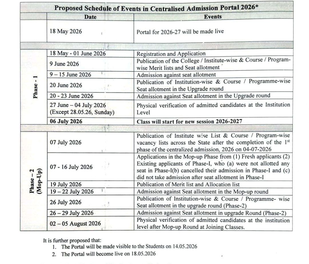
Important Dates
View